
Living quite close to Worcester, we often pop into the city for a walk along the river.
Worcester is a city steeped in history, where many battles have been fought.

Looking towards Diglis Lock from Diglis Bridge last week.
The River Severn was very calm, and flowing at a more normal depth, unlike the video I posted last November in a previous blog post.
About a mile from this very modern bridge is Powick Bridge, a site of one of the major battles of the English Civil War during the 17th century.
We continued over the bridge and headed towards Worcester Cathedral. The cathedral’s tower was chosen by King Charles II to watch over the Battle of Worcester.
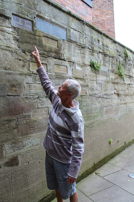
Worcester Cathedral’s Watergate wall has dates recorded on it of the varying flood levels when the Severn has burst its banks. The highest recorded level was in 1770 (the large plaque) followed closely by March 1947.
To the right just above T’s head, is a marker (with greenery growing under it) for July 2007, the highest level in my lifetime.
The river’s normal level is at least 10-15 feet below the footpath he’s standing on.
We walked into the town, and along Friar Street, a very picturesque street full of beautiful timber framed buildings. I wonder what tales those walls could tell.
 Having a while to wait before our train home, we called into King Charles House. This ancient building, which is now a pub, is one of Worcester’s most historic buildings.

I’ve never been too interested in the history of the British Monarchs, but as T, who has a great interest in the English Civil war, launched into a history lesson with the poor barman, I started to find it very interesting.
King Charles House is the building from where King Charles II escaped his enemies after the Battle of Worcester in September 1651. This battle marked the end of the English Civil War, when the Royalists were defeated by Oliver Cromwell’s Parliamentarians.
The King who eventually escaped to France, first headed north towards Shropshire, then, almost doubling back on himself, headed for the south coast.
Below is a map of his route.
For anyone interested, as I’m not going to launch into a history lesson, there is some good information here.
I have often walked Sal and Jasp on the part of The Monarchs Way that passes nearby our home, without knowing the full reason for its name, but the cogs of my brain where slowly putting two and two together.

So today, we decided we’d would walk in a few more of Charles II’s footsteps.

Is this really the route he took?
If it is, according to the above map, On September 10th 1651, he would have been heading towards where I am standing on his way south.
After doing a spot of research for this post, it appears we’ve trodden in his footsteps quite recently too.
When he reached the south coast, Charmouth was another place he passed on his escape route.

I doubt he’d have had time to look for fossils though 😉
** I have added quite a few links to this post. Because of all the history involved, I felt it would make for heavy reading and may be off putting, but for anyone with an interest, they are quite informative.**


